Why Is Berlin's Founding Year 1237? Cölln, Medieval Berlin and the City Before 1933
- Yusuf Ucuz

- Jun 10
- 7 min read
Updated: Jul 15
Berlin's official founding year is 1237. That is the date on the oldest surviving document that mentions the town of Cölln, Berlin's twin settlement on the other side of the Spree. Berlin itself shows up in the written record a few years later, in 1244.
So when the city celebrated its 750th birthday in 1987, the math pointed back to 1237. Here is the strange part: almost no walking tour in this city ever mentions it. Most tours compress 800 years of history into "and then 1933 happened." I built my route through the historic centre around the older story, so this post is the long version of the question I get asked most often.

Here is the short timeline before the details:
Around 1170 to 1200: settlements grow on both banks of the Spree, at one of the easiest crossing points in a swampy valley.
1237: Cölln is mentioned in a document for the first time. This becomes Berlin's official founding year.
1244: Berlin is mentioned for the first time.
1280: Berlin's town seal shows bears for the first time, long before the bear becomes the city's most famous symbol.
1307: Berlin and Cölln form a political union with a shared town hall.
1432: the two towns formally merge into one municipality, though their relationship with the ruler remains tense.
1415 to 1417: the Hohenzollerns take over Brandenburg. In 1443 they begin the palace in Cölln, on the site of today's Humboldt Forum.
1710: Berlin, Cölln, Friedrichswerder, Dorotheenstadt, and Friedrichstadt merge into a single royal capital called Berlin.
Two Towns, One River
Medieval Berlin was not one city. It was two.
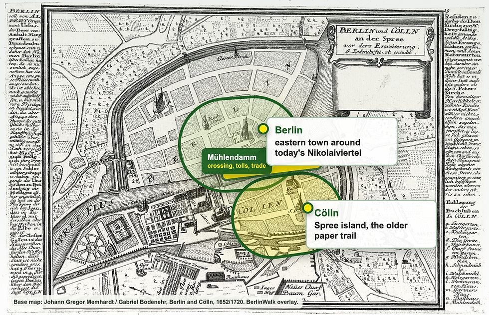
Cölln sat on the Spree island, around today's Petriplatz, Fischerinsel, and the later palace/Humboldt Forum side. Berlin sat on the eastern bank, roughly where the Nikolaiviertel stands today. The northern part of the same island is what visitors now know as Museum Island, which is why the old Cölln story is often hidden under museum language.
A mill dam and river crossing connected the two settlements. That crossing is the entire reason the city exists.
The Spree valley was wet, wide, and awkward to move through. The Mühlendamm created one of the reliable places where merchants could cross, haul goods, pay tolls, and ideally spend money. Two towns grew rich on that bottleneck.
They were neighbours, business partners, and rivals. Each had its own church, its own town hall, its own council, and its own opinion about the other. The 1307 union was less a romantic merger and more a defensive arrangement: together they could afford better walls, coordinate trade, and push back against the robber barons who harassed routes through Brandenburg.
The first town hall connected with this double town stood near the medieval heart of today's city. Its distant institutional successor is the Rotes Rathaus, still Berlin's city hall and still standing almost exactly where the early urban story began.
Why 1237 Counts as the Founding Year
Here is the honest answer: 1237 is a documentation date, not a birth date.
Medieval towns did not get neat founding certificates. They appear in history when someone happens to write them down, usually in a property record, a church document, or a legal dispute. The 1237 document mentions Symeon, a priest from Cölln, and that parchment simply happens to be the oldest one that survived.
Archaeologists have found older traces under central Berlin. In 2008, oak timbers discovered at Petriplatz were dated to the late 12th century, probably around 1183. That does not make 1183 the official birthday, but it does confirm what the written record already suggests: both towns were functioning communities before any surviving document named them.
So Berlin is officially 1237 and unofficially older, which feels appropriate for a city that has never been tidy about its own story.
The 750th anniversary in 1987 came with its own twist. The city was divided into East and West, so each half threw a separate, competing birthday party for the same city. Even Berlin's birthday was split by the Wall.
What "Berlin" Actually Means
The bear on Berlin's coat of arms is one of the best pieces of medieval branding in Europe, and it probably grew from a misunderstanding.
The name Berlin is commonly linked to an old Slavic root connected with swamp or marshland. Before German-speaking settlers expanded into the region, this area was Slavic territory, and the wet Spree valley had earned an accurate, unglamorous name. Cölln's origin is less certain, though it may echo the great trading city of Cologne.
Medieval Berliners either did not know or did not care. The name sounded close enough to Bärlein, "little bear" in German, for bears to walk onto the town seal by 1280. The city's symbol then kept evolving until the bear became Berlin's central visual shorthand.
That makes Berlin a swamp by name and a bear by logo. It would not be the last time the city embraced a myth more charming than the facts.
Where You Can Still Touch Medieval Berlin
People assume nothing survived the 20th century. More survived than you think, and most of it sits within a short walk of Alexanderplatz.
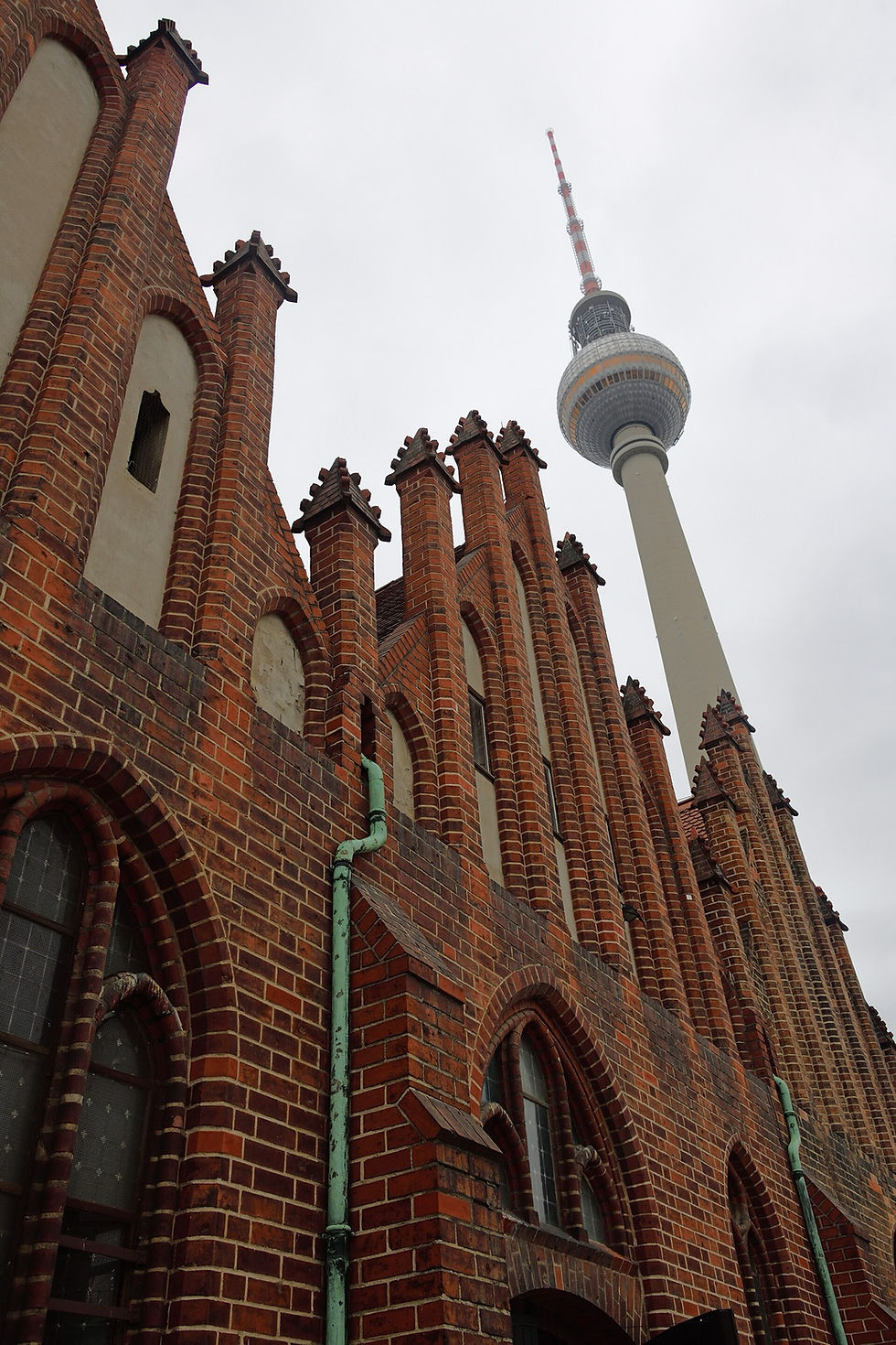
St. Mary's Church (Marienkirche): probably built after 1250, first mentioned in 1292, and still standing in the shadow of the TV Tower. Inside is a late-15th-century Dance of Death mural. This is a stop on my tour.
Nikolaikirche: Berlin's oldest church, begun around 1230, now the centrepiece of the rebuilt Nikolaiviertel.
The medieval city wall: a fragment of the 13th-century town wall survives on Littenstraße, hiding in plain sight behind office buildings.
Zur Letzten Instanz: a restaurant tracing its hospitality history to 1621, built against the line of the old wall.
The Franciscan monastery ruin (Klosterkirche): a 13th-century brick ruin left open to the sky, one of the quietest places in the city centre.
The street plan itself: the curve of streets in the Nikolaiviertel still follows the medieval layout, even though most buildings are reconstructions.

If you have ever wondered why Berlin has no picture-perfect old town, these scattered fragments are the answer: the old town existed, and the 20th century took most of it. War destroyed part of the medieval quarter, and the GDR demolished much of what remained to build the open spaces you see around the TV Tower today.
This is why medieval Berlin feels like a treasure hunt rather than a postcard. You do not stand in one preserved square and say "here it is." You move through fragments: a church wall, a street curve, a ruined monastery, a piece of city wall, a bridge line that still matters. If you want to follow those fragments in order, the Medieval Berlin Audio Tour walks from the World Clock at Alexanderplatz through Nikolaiviertel to Lustgarten.
From Twin Towns to Capital
The rest of the story moves fast.
In 1415, Emperor Sigismund granted Frederick of Hohenzollern the title of Margrave and Elector of Brandenburg. The family would dominate Brandenburg, Prussia, and later Germany until 1918. Berlin's relationship with the Hohenzollerns began as a power struggle, not a love story.
In 1443, Elector Frederick II laid the foundation stone for a palace on the Cölln side of the river, on the exact site where the Humboldt Forum stands today. Locals hated the project enough to flood the construction site by opening the Spree locks, an episode remembered as the "Berlin Displeasure" or "Berlin Indignation." It did not work. The palace rose anyway, and by 1486 it had become the permanent residence of the Brandenburg electors.
That single decision changed Berlin's future. A merchant double town became a residence city. Trade still mattered, but court politics, administration, military power, and royal ambition began pulling the city in a new direction.
In 1710, the old towns and three newer neighbouring towns were merged into one royal capital. Cölln, the older sibling on paper, lost the naming contest. The unified city took the name Berlin, and Cölln slowly faded into a footnote that even most Berliners no longer recognize.
Today its old island carries the Humboldt Forum, the Berliner Dom, and five world-class museums. Almost nobody who visits knows they are standing on the older half of the city.
Why Most Tours Skip All of This
Berlin's 20th-century history is enormous, and it deserves the attention it gets. But when a tour starts in 1933, you see a city that is 90 years old. When it starts in 1237, you see a city that survived plague, fire, war, occupation, division, and several complete identity changes, and kept going.
That is the Berlin I show people. My free walking tour runs about 2 hours through the historic centre, starting at Alexanderplatz, past the medieval survivors, across the old Cölln island, and ending at Hackescher Markt. The medieval city is where the story begins, and it is the part almost everyone else leaves out.
For the route itself, see the full Berlin walking tour route. If you want to understand the rebuilt old town more deeply, read my guide to the Nikolaiviertel. For the church that still anchors this older story, start with St. Mary's Church.
If you want the older city explained in person, join my Berlin Free Walking Tour. I start at the World Clock, because Alexanderplatz is not just a transport hub. It is the edge of the old story.
For the next step, my practical Berlin guides to the Hohenzollern story behind Berlin can help with the next practical detail.
Image credits
Images: Nikolaiviertel and TV Tower by Manuel Kapunkt via Pexels (free to use); resized for BerlinWalk. Berlin und Cölln an der Spree, 1652/1720.jpg) by Johann Gregor Memhardt / Gabriel Bodenehr via Wikimedia Commons (public domain); resized for BerlinWalk. Berlin Marienkirche Exterior 0326 02.jpg by Dosseman via Wikimedia Commons (CC BY-SA 4.0); resized for BerlinWalk. Mittelalterliche Berliner Stadtmauer.jpg by Ulrichhobby via Wikimedia Commons (CC BY-SA 4.0); resized for BerlinWalk.