The Spree River: The Waterway That Built Berlin
- Yusuf Ucuz

- Mar 2
- 10 min read
Updated: Jul 1
Every famous city has a river people know by name.
London has the Thames. Paris has the Seine. Rome has the Tiber. Berlin has the Spree, but many visitors barely notice it.
That is strange, because the Spree is not a decorative detail. It is one of the main reasons Berlin exists where it does.
The river shaped the first settlement, the first bridge, the first trading routes, the old twin towns of Berlin and Coelln, the palace area, Museum Island, Cold War borders, modern boat tours, waterfront development and some of the best views in the historic centre.
If you walk through central Berlin without understanding the Spree, the city can feel like a strange collection of unrelated monuments.
If you follow the river, Berlin starts to make sense.

The Short Answer
The Spree River helped build Berlin because it gave the medieval settlement water, trade, transport, defence and a reason for bridges to form.
Old Berlin grew around the river and its islands. The former town of Coelln sat on Spree Island, while Berlin developed on the opposite bank. Over time, those settlements became one city.
That old river logic is still visible today:
Museum Island sits between branches of the Spree.
Nikolaiviertel marks the old city core near the river.
Humboldt Forum stands where the palace faced the water.
Liebknecht Bridge and Friedrichsbruecke give some of the best historic-centre views.
Boat tours still use the Spree as an easy way to read the city from east to west.
The Spree is not Berlin's biggest landmark, but it is one of its best storytellers.
Why Berlin Is Here
Berlin did not begin as a grand capital.
It began as a practical river settlement.
In the 13th century, the twin towns of Berlin and Coelln grew beside the Spree. The river made trade easier, created a natural crossing point, and gave the early town a defensive and economic reason to exist.
Berlin.de's overview of Alt-Berlin describes the original part of Berlin as including Spree Island, the former Coelln, with Museum Island and Fischerinsel, plus Alt-Berlin with Nikolaiviertel. That is the city in its oldest geographic form: river, island, crossing, market, church, settlement.
This matters because Berlin is not a city that grew around one perfect cathedral square. It grew around movement.
Goods moved by water. People crossed bridges. Power gathered beside the river. Markets formed where routes met.
That is why so many central landmarks are close to the Spree. The river came first. The capital came later.
Berlin and Coelln: Two Towns, One River
Old Berlin was not one neat town at the beginning.
It was two neighbouring settlements.
Berlin sat on one side of the Spree. Coelln sat on the island. A bridge connected them. That bridge connection was not a small detail. It was the practical heart of the place.
Think about what a bridge meant in the Middle Ages:
trade could be controlled
tolls could be collected
markets could grow
people could settle near predictable movement
political power could watch the crossing
The river did not just give Berlin water. It gave Berlin a reason to become a meeting point.
That old logic survives in the way central Berlin still feels. You move from Alexanderplatz to Nikolaiviertel, from Rotes Rathaus to the Humboldt Forum, from Museum Island to Hackescher Markt, and the Spree keeps appearing between the places like a quiet thread.
If you want the deeper old-town context, read my guide to why Berlin does not really have an old town and the story of Berlin's lost neighbourhood.
Museum Island Exists Because of the River
Museum Island is one of the clearest examples of the Spree shaping Berlin.
The name is not poetic. It is geographic.
The museums stand on an island formed by the Spree and its channels. Between 1830 and 1930, Prussia built five major museums there: Altes Museum, Neues Museum, Alte Nationalgalerie, Bode Museum and Pergamonmuseum.
VisitBerlin notes that Museum Island is surrounded by the River Spree in the heart of Berlin. That simple physical fact made the ensemble feel separate, ceremonial and monumental.
The river created an edge.
It gave the museums a stage.
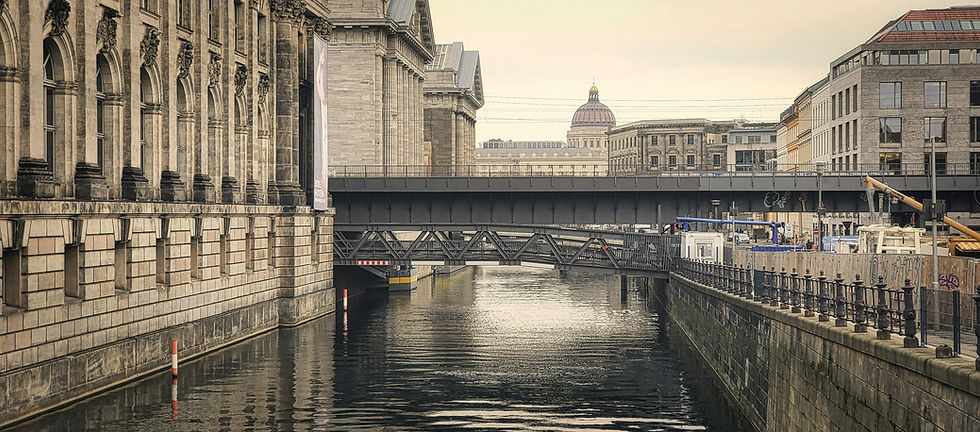
It also gave Berlin one of its most beautiful walking routes. Stand near the water by the Altes Museum, cross toward Friedrichsbruecke, or look back from Liebknecht Bridge, and you can see why Prussia wanted culture to feel like power.
For more detail, read my guide to why Prussia built an entire island of museums.
The Palace, the Cathedral and the River View
The Spree also shaped the symbolic centre of Berlin.
The old Berlin Palace stood beside the river. Today, the Humboldt Forum occupies that site. Across the water, the Berliner Dom rises beside Museum Island.
This is one of the best places to understand Berlin visually. From Liebknecht Bridge, you can see the reconstructed palace facade, the Cathedral, the Spree and the TV Tower in one frame.
That view is not just pretty. It compresses centuries:
royal and imperial Berlin
World War II destruction
GDR-era absence and rebuilding
post-reunification reconstruction
modern tourist Berlin
The river holds those pieces apart just enough for you to read them.
That is why I keep sending visitors to Liebknecht Bridge and Friedrichsbruecke. Bridges are not only crossings in Berlin. They are viewing platforms.
Bridges Made Berlin Legible
If the Spree created Berlin's geography, bridges made that geography usable.
This is easy to overlook today because crossing the river feels effortless. Trams, bikes, buses, pedestrians and tour groups move over the water all day. But in an older city, a reliable bridge was a serious piece of infrastructure. It told people where to trade, where to gather and where power could be watched.
That is why bridge views are so useful in Berlin.
They are not random scenic points. They sit where movement has mattered for centuries.
On Liebknecht Bridge, the city opens in two directions. One side looks toward the Berliner Dom and Museum Island. The other side looks toward the Humboldt Forum and the old palace site. The TV Tower rises behind it all like a reminder that the 20th century never leaves the frame.
On Friedrichsbruecke, the river feels quieter. You see Museum Island from a softer angle, with the water narrowing the city into stone, railings and reflections. It is less dramatic than Liebknecht Bridge, but often more revealing.
Those two bridges are close together, yet they tell different stories. One is panoramic. One is intimate.
That is Berlin on the Spree.
What You See From the Water
A boat tour can make Berlin feel unusually coherent.
On foot, the historic centre sometimes arrives in fragments. A church here. A museum there. A reconstructed palace, a socialist tower, a bridge, a government building, a modern office facade. The city can feel like someone shuffled several centuries together and forgot to label the piles.
From the water, the sequence is clearer.
Buildings line up along the river. Bridges mark transitions. Museum Island becomes an island, not just a name. The Cathedral and Humboldt Forum face each other across water instead of floating separately in your mental map. The government quarter reads as a planned riverfront landscape rather than a set of isolated buildings near the Reichstag.
That does not mean a boat tour gives deeper history than a walk. Often it does not. But it gives physical orientation.
That is valuable in Berlin.
Use the boat for shape. Use a walking tour for meaning.
The River and Berlin's Missing Old Town
The Spree also helps explain one of the most confusing things about Berlin: the old centre does not feel old in the way visitors expect.
Near Nikolaiviertel and the old Marienviertel, the river once ran beside dense streets, churches, markets and houses. War damage, postwar clearance and GDR planning changed that landscape dramatically. Some historic fragments remain, but much of the old city fabric disappeared.
The river stayed.
That creates a strange effect. The water still traces the old logic of Berlin, even when the buildings around it have changed beyond recognition.
Near Nikolaiviertel, you can still feel the medieval origin story. Near Museum Island, you feel Prussian cultural ambition. Near the Humboldt Forum, you feel the palace debate and the problem of reconstruction. Near the East Side area, you feel the river as division, nightlife and development pressure.
The Spree is the continuity line.
It is not untouched. It has been engineered, bordered, crossed, polluted, cleaned, commercialised and photographed. But it still shows where Berlin began.
The Spree Is Not the Seine, and That Is Fine
Do not expect the Spree to behave like the Seine.
The Seine announces Paris. The Thames announces London. The Spree is more modest in the centre of Berlin. It slips between stone walls, museum facades, government buildings and modern developments. Sometimes it feels hidden until you are suddenly standing above it.
That modesty can disappoint visitors who expect a grand river promenade.
I think it makes the Spree more interesting.
Berlin is a city of interruptions. The river fits that personality. It appears, disappears, bends, narrows, reflects, divides, reconnects and keeps moving through places that have been rebuilt several times.
The best way to enjoy it is not to search for one perfect riverside boulevard.
Follow it in pieces.
Cross a bridge. Walk a short embankment. Take a boat if the weather is good. Pause by Museum Island. Look back from the Humboldt Forum side. Notice how many important buildings need the river to make visual sense.
Once you do that, the Spree stops being background.
The Spree During the Cold War
The Spree became darker during the Cold War.
In some parts of divided Berlin, the river formed part of the border landscape. The exact legal and physical border line varied by section, but the effect was brutal: water that once connected the city could become part of a deadly separation zone.
This is especially important around the inner-city Spree and the East Side area. The river did not always look like a wall, but it could function like one. Banks, patrol zones, restricted access, and the political fear around crossing made the water part of the division.
That history is easy to miss today.
Tour boats move calmly through the centre. People sit by the water with coffee or beer. Bridges feel ordinary. The river looks peaceful.
But in Cold War Berlin, peaceful surfaces could hide dangerous lines.
For a wider division map, use my East and West Berlin guide.
The Spree Today
Modern Berlin uses the Spree in several different ways at once.
It is a sightseeing route. Berlin.de's river cruises and boat trips page lists city Spree cruises featuring central highlights such as Berliner Dom, Museum Island and the Reichstag. VisitBerlin also sells one-hour Spree boat tours through famous sights and modern buildings.
It is a transport and waterway system. The federal WSA Spree-Havel office lists the Spree-Oder-Wasserstrasse as one of the waterways in its area.
It is a leisure zone. People walk, cycle, sit, photograph, drink coffee and watch boats pass.
It is also a development battleground. Riverfront land is valuable. Creative spaces, clubs, offices, hotels, apartments and public promenades all compete for space near the water.
That tension is very Berlin.
The river is public in feeling, but the banks around it are often contested.
Should You Take a Spree Boat Tour?
Yes, if you understand what it is good for.
A Spree boat tour is not a replacement for walking Berlin. It is a different angle.
From the water, the city becomes easier to read in long lines: Museum Island, Berliner Dom, government quarter, bridges, modern offices, old stone, glass, cranes, embankments.
It is especially useful if:
your feet need a break
you want photos from a lower river angle
you are travelling with someone who cannot walk all day
you want to connect Museum Island and the government quarter visually
you like seeing bridges and facades from below
It is less useful if you want deep historical context at every stop. Boat commentary can be light, crowded, multilingual or generic, depending on the operator.
My recommendation: walk the historic centre first, then take a boat tour if the weather is good and you want a relaxed second perspective.
For ticket options, compare my Berlin boat tours and river cruises guide.
Best Places to See the Spree on Foot
You do not need a boat to appreciate the river.
For most visitors, these are the best walking spots:
Liebknecht Bridge: Best single view of the Berliner Dom, Humboldt Forum, Spree and TV Tower layers.
Friedrichsbruecke: Quieter Museum Island river view, especially good for photos and a slower pause.
Nikolaiviertel pier: Berlin.de notes that the pier is near St. Nicholas' Church in the historic old quarter, with the reconstructed Berlin Palace opposite and Museum Island, the TV Tower and other sights close by.
Museum Island river edge: Best for understanding why the museums feel like a cultural island.
Reichstagufer and Friedrichstrasse: A useful city-centre stretch for boat piers, government-quarter direction and river movement.
Oberbaum Bridge: Best for the Spree as a modern, nightlife, East-West and Friedrichshain-Kreuzberg river view.
If you want a simple route, start near Alexanderplatz, walk through Nikolaiviertel toward the Humboldt Forum, cross Liebknecht Bridge, continue along Museum Island, pause at Friedrichsbruecke, then finish toward Hackescher Markt.
That is a short walk, but it explains a lot.
Why Visitors Miss the Spree
Many visitors miss the Spree because Berlin does not market itself as a river city in the same way Paris or London does.
The river is narrower, quieter and less theatrical than the Seine or Thames. It often slips between buildings rather than dominating the city. Central Berlin also distracts you with huge historical objects: TV Tower, Berliner Dom, Humboldt Forum, Museum Island, Brandenburg Gate, Reichstag.
But that quieter role is exactly why the Spree matters.
It connects the sights without shouting.
It explains why they are where they are.
Once you start noticing the river, Berlin feels less random.
Sources and Further Reading
Useful official and planning sources:
Related BerlinWalk guides:
Walk the River Story With Me
My tip-based Berlin walking tour crosses the Spree, pauses at key river views and uses the water to explain why the old city, Museum Island, the palace site and modern Berlin line up the way they do.
It is a 2 hours introduction to Berlin with 12 stops, no fixed upfront price, and a route from Alexanderplatz toward Hackescher Markt.